Every Country Event is Unique
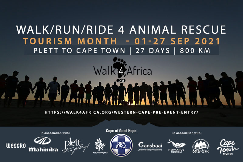
In South Africa, our inaugural multi-stage event, the “Walk/Run/Ride 4 Animal Rescue” fundraiser from Plettenberg Bay to Cape Town will take place during Tourism Month (01-27 September 2021). This event aims to boost post-COVID-19 tourism recovery by fostering public wellness through mass outdoor participation while fundraising for our beneficiaries; the Garden Route SPCA and the Cape of Good Hope SPCA.
HAVE QUESTIONS ABOUT THIS EVENT?
Read our Frequently Asked Questions (FAQ) page (click the button below).
Hopefully, you’ll find answers to any questions you may have in this list.
How will the Walkathons work?
Ideally, all 40 host country events will be launched simultaneously to coincide with World Tourism Day on 27 September each year.
As mentioned previously, the Country Steering Committees (CSC) will decide on the walking route/s to be followed and may be a single day event covering a set distance (usually within close proximity to major coastal city/town locations for ease of participant access) or a multi-day event over a longer distance.
For multi-day events, the CSC may arrange camping facilities on the beach or arrange preferential accommodation booking rates with hospitality establishments along the walkathon route. If beach camping is not possible, the CSC will arrange a suitable venue for each days walkathon route end dinner and presentations.
In general terms, there may be three groups of walkers; a Walking Group, an Advance Group, and a Support Group. Here’s a brief summary of each:
Walking Group:
These are the volunteers and hosted guests actually doing the day-to-day walking. Volunteers will most likely be domestic tourists who have registered to walk pre-defined distances/days and voluntarily elect to raise crowdfunding donations to sponsor their walk.
Hosted guests will be both local and international eco-tourists who have purchased all-inclusive tour packages to participate in pre-defined distances/days. Hosted guests may also include celebrities or ambassadors, whose presence and support will be beneficial to raising awareness of the W4A project.
The number of walkers that participate in the Walking Group on a day-by-day basis will be limited and the total numbers determined by the Country Steering Committee. This number will include the Advance Team and Support Team member numbers.
The reasons for this limitation include; environmental impact (some stretches of coastline may be more sensitive than others), accessibility (some areas may be easier to get to than others, especially for shuttle services), capacity (the number of tents that can be set up at route over-night camping points may differ), and demand (scarcity creates higher demand and perceived value).
Advance Group:
These are the contracted suppliers. This group includes the mobile camping outfitter and catering supplier who will move ahead of the walking group to set-up facilities for the group’s arrival each day and break-camp the following morning for relocation.
Ideally, this supplier should be sourced locally with casual labour sourced from local communities. This group also includes the contracted private security team (an armed guard will accompany the walking group each day and patrol the campsite each night on a rotational basis, so they will need a base within the camp), and the medical first-aid team (to treat blisters, stings, cuts and grazes, etc (they may need a quad bike to transport patients along the beach to the base camp).
And then there’s hosted media groups who will need tech facilities at the camp such as satellite internet for sending social posts, etc. The advance group may also need to hire boats to ferry walkers across wide river estuaries or mangroves that block the way along parts of the coastline. Some country routes may also have massage facilities available on the beach – assuming that trained masseuse are available locally.
Support Group:
The Support Group is an essential part of the walkathon effort. It is comprised of research academics, advisors, teachers, media, film crews, sponsors, etc, who will be fulfilling the actual Mission of the W4A project.
For example, a university or society may want to send academics to conduct local research into marine/beach ecology issues or conduct anthropology research.
We’ll need tourism advisors to work with local communities to identify and develop new tourism products, or agricultural initiatives, for job creation.
We’ll need teachers to visit local schools and community halls along the routes and educate students and locals about responsible tourism and environmental protection, why they matter, and what they can do to create a better future for the planet.
This team also includes hosted media such as bloggers, film crews, and journalists to report on progress and raise social media awareness of the W4A project. This team will also require accommodation or use the beach camp as their nightly base.
Note: Although the W4A concept aims to source all procurement (camping, catering, land transport, labour, etc) within each host country, some of these services may need to be brought in. In addition, allowance must be made for the transportation of international support groups between host countries.
What’s the Procedure?
Although walking speeds can vary greatly depending on many factors such as height, weight, age, terrain, surface, load, culture, effort, and fitness, the average human walking speed is about 5.0 kilometres per hour (km/h), or about 1.4 meters per second.
Assuming then, that walkers average 5 km/h for a maximum of 6-hours, we can expect them to cover 30 km per day. Of course, this time and distance will vary according to the terrain and the best position to locate the overnight campsite. Some walk-days may, therefore, be longer than other walk-days.
In terms of actual procedures, the walk4africa.org website will detail each country’s route using Google Maps and showing estimated daily distances and overnight camp locations (as determined by the Coastal Odyssey expedition). Once each country walkathon goes live, the route progress will be plotted and updated hourly using live GPS data.
Registration for all walk entries will be free of charge (with an option to either make a one-off donation or to set up a crowdfunding page for pledges) and done in two phases; an Online Registration before the event, and an On-Site Registration on the day of the event.
Below is a rough guide on how this procedure works:
A. Online Registration
This website (walk4africa.org) will be the main portal for public registration to participate. There will also be pre-populated crowdfunding pages for walkers to raise donations for their walk. The procedure will be as follows:
- User Registration: Basic details for username/password creation with double-opt-in confirmation for security and T&C/Indemnity acceptance.
- Account Confirmation: User clicks on an email link, logs-in, and continues with the step-by-step registration process.
- How would you like to participate? Options:
A. Self-Walk – Individual (info icon: I’m registering to walk by myself without sponsors as part of the walkathon team).
B. Self-Walk – Group (info icon: I’m registering for a group to walk without sponsors as part of the walkathon team).
C. Sponsored Walk – Individual (info icon: I want to get friends to sponsor my own walk as part of the walkathon team).
D. Sponsored Walk – Group (info icon: I want to register for a group to walk as part of the walkathon team and to get sponsors). - Would you like to make a donation? Selection options: Yes. No.
If Yes, a pop-up window appears with amount options, which are added to a “shopping cart” for final step check-out via secure payment gateway (PayPal, Bank EFT, Visa, Mastercard, etc). If registering to get sponsors, a personalised crowdfunding page link is generated at the end of the registration steps. - How many days would you like to walk? Selection options:
Day Walker (info icon: day-walks last for about 4-10 hours and cover between 20-50 km starting at 09h00) or Multi-Day Walker (info icon: Multi-day walks require pre-booking accommodation or overnight camping on the beach). - Select your walk day dates (calendar showing dates with distances)
- How will you get to the beach? Selection options:
7.1. Self Drive (info icon: Make your own way to each day’s departure point). Upgrade options:
7.1(a) Secure car parking with return shuttle (info icon: Price);
7.11(b) Car delivered to selected end/exit point (info icon: Price).
7.2. Shuttle Drive (info icon: Meet at the central point – see options and prices here – and be driven to your selected beach departure point and back to the central location after your walk). - Will you carry your own gear or need assistance? Selection options:
1. Self Assist (info icon: Carry your own kit i.e water, clothing, food and camping equipment).
2. Hosted Assist (info icon: Have your kit transferred to each nights accommodation establishment or campsite and your tent erected, ready for your arrival at XX price per day).
3. Fully Hosted (info icon: Bring only your clothing, wash bag, towel, and water bottle/hydration pack. See Packaged Tours.
B. On-Site Registration
When walkers arrive at each day’s beach departure point, they will be registered on-site using their pre-issued number and given a colour coded material wristband to wear. These will be colour coded for ease of recognition; Green = Self-Assisted Walker, Purple = Assisted Walker, and Red = Hosted Walker. This will make it easier for the advance group to know which services are being provided for the walker.

Packaged Tours
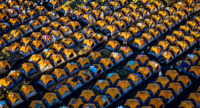
Where beach camping is possible, the contracted supplier (advance team) will provide the required number of pre-booked 2-man tents for each night and erect these on the beach. Each tent will be kitted with quality foam mattress (1 or 2 depending on single or sharing), pillows, linen, washbasin, interior lamp, and exterior lamp (depending on the season, blankets/heater or fans and mosquito nets/repellent may be needed).
The tents will be numbered (walkers wristband/registration number) and erected side-by-side in rows, with netted ground-sheet pathways between rows, and leading to the ablution (mobile toilets), hot/cold showers (him & hers), and dining/refreshment facilities. All meals (breakfast, lunch pack, and dinner), facilities will be provided. Tea/coffee, soft drinks and alcoholic beverages (where permitted) will be available for sale at the campsite. Massage facilities may also be available. There could be an area allocated for locals to sell their arts & crafts at the campsite.
Where beach camping is not possible, the registration process will allow for local accommodation bookings and will include a shuttle service to transport the walker from the walkathon end point to the accommodation establishment.
The packaged tour pricing will be determined by the local steering committees in each of the 40 host countries and will include registration, transport (shuttle transfers) from central city/town locations to the beach (or pre-booked accommodation) for locals, while return airfares, airport meet & greet, and beach transfers will be included for international packages.
Whoever the local steering appoints as the lead tour operator/ground-handler will cost the various package tour itinerary pricing (refer on-line registration procedure above).
Once itinerary pricing has been established, online bookings will be made available on this website, on the lead suppliers website, as well as on selected tour operator/travel agent partner websites (linked to this site).